.webp)
.jpg)
El Niño’s arrival could bring heavy rains, flooding, and higher tropical cyclone activity to some parts of the world, while bringing heat, drought, wildfire, and food insecurity to others.
- An El Niño has been declared by meteorological agencies in the U.S.
- El Niño can have major impacts on global extreme weather, though its exact impacts can vary year to year.
- Its impacts could become even more intense in a changing, warmer world.
- A strong El Niño could make 2027 the hottest year ever, and may represent a global climate shock.
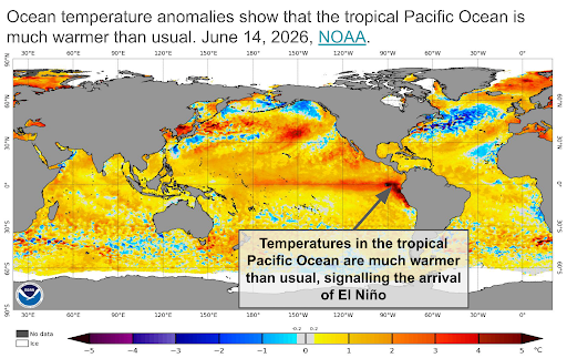
El Niño Has Arrived.
As summer begins in the Northern Hemisphere, one topic has dominated the weather and climate world – the imminent approach of an unprecedented El Niño. El Niño is a phenomenon marked by the emergence of warmer than usual ocean temperatures in the eastern tropical Pacific Ocean. But El Niño does not affect just the Pacific Ocean. Its impacts on rainfall, drought, temperatures, and weather patterns are felt across the globe.
The U.S. National Oceanic and Atmospheric Administration officially declared El Niño’s arrival on June 11, 2026. While other meteorological organizations such as the World Meteorological Office and Australia’s Bureau of Meteorology have not (yet) officially confirmed El Niño’s arrival, these organizations all agree – El Niño’s formation is imminent.
From the Pacific to the Planet: How El Niño Works
El Niño is a natural, recurring oceanic phenomenon that happens every 2 to 7 years on average. Its first records are attributed to Peruvian fishing communities, who noticed that the oceans were much warmer than usual every few years, leading to decreased fish catch. Since the warm oceans typically occurred around Christmas, they named this phenomenon "El Niño" — meaning "the little boy." As humans were able to monitor more and more of the globe, they realized that the warm ocean temperatures expanded across the Pacific, directly or indirectly impacting much of the world.
Normally, the western tropical Pacific is warmer than the eastern part due to the trade winds – permanent, east-to-west winds along the equator that helped sailors cross the oceans long ago. Most of the time, these winds blow from South America toward Indonesia and the Philippines, moving surface water westward. The water pulled away from South America is replaced by cold deep-ocean water via upwelling, keeping South American coastal waters cold and the west Pacific warm. When the trade winds slow down, less water moves westward, allowing the eastern and central Pacific to warm more than usual and the western tropical Pacific to cool slightly — the hallmark of El Niño conditions. The build-up of oceanic heat is then transferred to the atmosphere, driving warmer-than-average global temperatures and shifting regional rainfall patterns across much of the globe.
The weaker winds and warmer water shift the frequent equatorial rains eastward, leaving the western Pacific drier than normal while the eastern Pacific sees more rain than usual. These changes in winds and ocean temperatures modify atmospheric circulation, extending El Niño's reach well beyond the tropical Pacific. Thus, directly or indirectly, El Niño — and its colder-than-normal analogue, La Niña — impacts temperature and rainfall across many regions.
El Niño's direct impacts are felt most acutely along the Pacific rim: warm waters off South America's west coast drive local rainfall; warm Pacific waters fuel stronger-than-normal tropical cyclones; and drier conditions grip Indonesia and other western Pacific nations as storm systems shift east. For other regions, the influence is less immediate — as El Niño reshapes atmospheric circulation in the tropics, those changes propagate to other parts of the world like Africa, North America, and Australia. Indirect though they are, these effects are no less substantial.
By impacting temperature and precipitation for much of the globe, El Niños also have a considerable societal impact. El Niños affect flood risk and global crop yields, and El Niño years are associated with increased outbreaks of waterborne and mosquito-borne illnesses. Ultimately, El Niños are thought to reduce global economic growth by trillions of dollars – the 1982 - 1983 and 1997 - 1998 El Niños reduced global economic growth by $4.1 trillion and $5.7 trillion, respectively. El Niño also lowers life expectancy – the 1982 - 1983 and 1997 - 1998 El Niños lowered global life expectancy by an average of 5 - 6 months. While La Niña phases can have major consequences for some regions, their impact on global economic growth and life expectancy is much smaller than that of El Niños.
Expect Impact. Don't Expect Predictability.
There is no such thing as a “normal” El Niño. Studying the impacts of several El Niño events can provide a composite picture of how El Niños impact the globe. But in many regions, the ways in which El Niño influences regional weather and climate are complex, and influenced by many other factors. Furthermore, modern records for El Niño only date back to about 1950, and the 1982 - 1983 was the first El Niño to be extensively studied, meaning there are relatively few El Niños for which we have extensive data. For example, two very strong El Niños had very different impacts on North America – the 2015 - 2016 El Niño was much drier than usual in California, even though El Niños are typically associated with wetter-than-normal conditions in California. The 2023 Atlantic hurricane season was more active than usual, despite the presence of an El Niño. This leads to a phrase often repeated by climate scientists: No two El Niños are the same.
El Niño matters, but it’s not the only factor that affects regional weather and climate. While El Niño is a useful predictor for weather and climate on longer timescales, it still only provides limited predictive skill in more remote regions like North America. Other atmospheric and oceanic patterns, such as ocean temperatures in the Caribbean Sea or the Indian Ocean, can interact with or override the impacts of El Niño. So while El Niño’s impacts will likely be felt in many locations, there will almost certainly be some regions that do not experience the patterns typically associated with El Niño. The fundamental challenge of predicting the impacts of an El Niño far in advance means we are usually in an El Niño before we know them with any confidence.
Robust uncertainty estimations and multivariate climate realizations can help model the impacts of El Niño. El Niño is a major factor in the natural variability of the climate – that is, the typical fluctuations of air and ocean temperature, wind, moisture, rainfall, and other factors that we expect on our changing planet. In global climate model simulations, El Niños naturally occur over the course of multi-decadal simulations. But since each model simulation is completely independent, El Niños don’t occur at the exact same time in every model run. Robust climate predictions therefore need many El Niños, La Niñas, and ENSO-neutral states to create a robust sample of the climate system, including high-quality uncertainty estimates in addition to mean predictions.
Global Impacts
El Niño's Hurricane Paradox
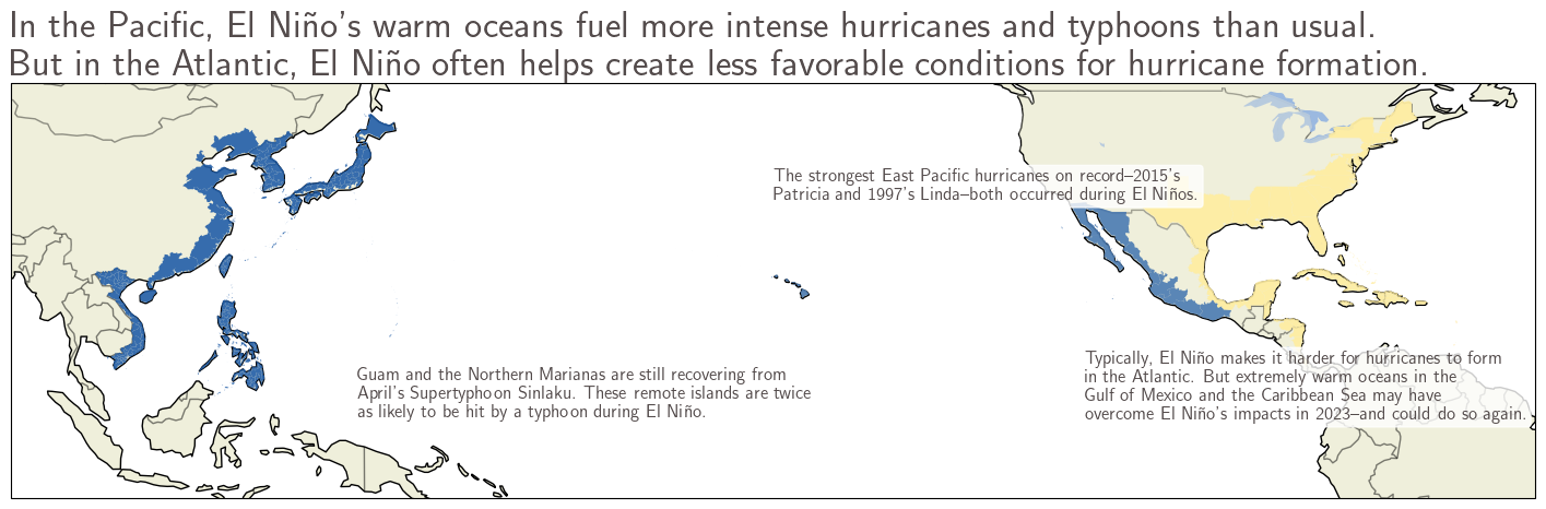
El Niño inhibits tropical cyclone formation over the Atlantic. El Niño affects global tropical cyclone behavior, but its impacts are different for different ocean basins. In the Atlantic, El Niño conditions generally make atmospheric conditions over the Atlantic less favorable to hurricane formation. But as the climate warms, this relationship may be changing. In 2023, the Atlantic had an above-average hurricane season despite the El Niño. Scientists suspect this active season was due to the record warm temperatures in the Caribbean Sea and the Gulf of Mexico. This year, seasonal forecasts are currently predicting a below-average hurricane season for the Atlantic--but an exceptionally warm Caribbean Sea or Gulf of Mexico could override the impacts of El Niño.
A warm Pacific Ocean means increased tropical cyclone activity in the Pacific during El Niño. While El Niño is often correlated with a less active tropical cyclone season in the Atlantic, the opposite is true in the Pacific, where El Niño’s warm ocean waters can supercharge tropical cyclones. The strongest East Pacific tropical cyclones ever – 2015’s Hurricane Patricia and 1997’s Hurricane Linda – both formed during strong El Niño years. And the rapid intensification of 2023’s Hurricane Otis, which exploded from a tropical storm to Category 5 strength in 24 hours, was likely fueled by El Niño. Accordingly, meteorological agencies and forecasting groups have predicted above-average tropical cyclone activity for the eastern and central Pacific as well as the western Pacific.
These forecasts mean that Hawai’i, the west coast of Mexico, and even southern California face elevated tropical cyclone risk, as do Japan, Korea, China, Taiwan, and the Philippines. Perhaps the most consequential region this year is Micronesia, where the Northern Mariana Islands and neighboring Guam were hit by the Category 5 Supertyphoon Sinlaku in April. These remote island nations are nearly twice as likely to be directly hit by typhoons during El Niño years. Recovery from Sinlaku could take months on these remote islands, and another hit later this year could be catastrophic.
Too Much Water: El Niño's Rainfall Regions
El Niño’s disruptions of the hydrological cycle bring heavy rainfall to often dry areas like Peru and the southwestern United States, and supercharges the seasonal rainfall in East Africa. In these regions, heavy rainfall often brings flooding and landslides leading to casualties, destruction of property and infrastructure, crop destruction, and disease outbreaks. Warming has already made these events more extreme – a pattern that will continue with further warming.
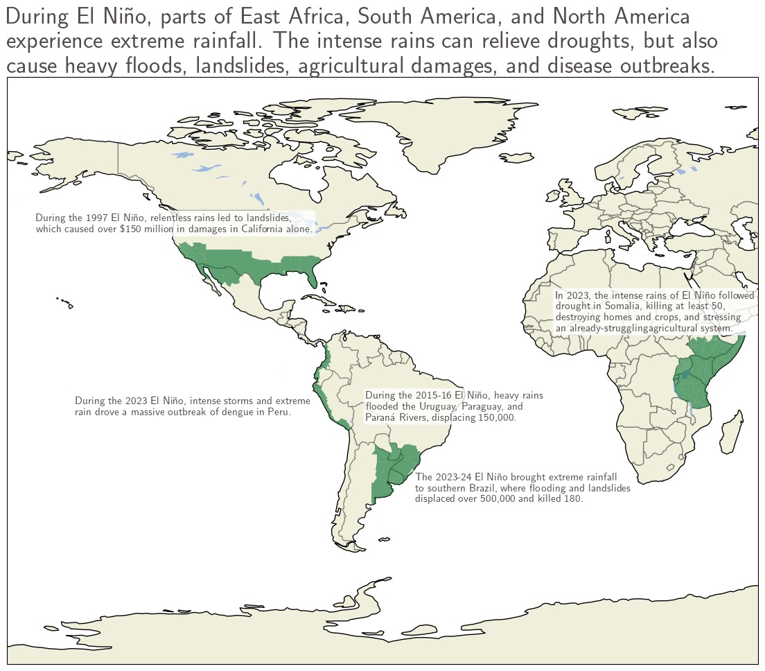
El Niño’s waters bring storms to coastal Peru, Ecuador, and Colombia. In a typical year, the Pacific coasts of Peru, Ecuador, and Colombia see relatively little rain. But during an El Niño, the unusually warm ocean temperatures energize storms and heavy rains along the coast. The heavy rainfalls disrupt agricultural production, increase landslide risk, and set the stage for major disease outbreaks, like Peru’s large 2023 - 2024 outbreak of dengue fever. Public health officials warn that a strong El Niño in 2026 - 2027 could set a new record for dengue outbreaks, and continued warming could double the exposure to dengue for over 250 million.
Heavy precipitation in the Andes and to the east during El Niño. Along with supercharging storms along coastal Peru and Ecuador, the warm waters of El Niño can fuel heavy rain and snow over the Andes Mountains and to the east, drenching soil and swelling rivers in Paraguay, Uruguay, northern Argentina, and southern Brazil. In December 2015 - January 2016, El Niño helped fuel the heavy rains that flooded the Uruguay, Paraguay, and Paraná Rivers, and it intensified the extreme rainfall in Brazil’s southernmost state, Rio Grande do Sul, that led to flooded rivers, triggered an estimated 15,000 landslides, and sparked outbreaks of waterborne illnesses. As the climate warms, these intense rain storms will almost certainly become more extreme, dropping even more rain in a single event.
On the heels of a drought, intense rains could spell disaster in East Africa. In Eastern Africa, El Niño often enhances the intense rains of the October - December wet season (the so-called “short rains”). The increased rainfall during El Niños often leads to heavy flooding and deadly mudslides, such as the 2023 rainfalls that displaced nearly 2 million in Kenya, Somalia, Uganda, Burundi, and Ethiopia.
East Africa is highly vulnerable to hydroclimate whiplash – that is, periods of extremely dry conditions immediately followed by extremely wet conditions, or vice versa. When extreme rain follows extreme drought, the consequences can be especially severe. Drought-stricken soils don’t absorb water as easily, leading to increased runoff and surface flooding. The 2023 El Niño saw Somalia suffer intense rainfall after a multi-year drought, wreaking havoc on Somalia’s already-strained agricultural system. Currently, much of East Africa is experiencing drought conditions, meaning that an intense short rain season could be even deadlier than usual following a months-long drought.
North America seeks drought relief during the summer monsoon and beyond. One of the primary ways El Niño impacts North America is its modification of the Pacific jet stream. It tends to make the jet stream stronger (meaning more frequent, rainier storms), and moves it slightly to the south. This means that El Niño events are generally associated with wet and cool autumn and winter conditions across the southern U.S. and northern Mexico, while the Pacific Northwest, western Canada, and Alaska are often warmer and drier than normal. El Niño events have often been drought-busters for the southern U.S., with many strong El Niños providing relief; though other El Niños, like 2023 - 2024, did little to alleviate drought.
And while a rainy winter would be welcome, especially after a record-warm winter in the western U.S., heavy rainfall brings its own risks, like the damaging landslides that accompanied the 1997 El Niño. Areas recently burned by wildfires are especially susceptible to flooding, and an active 2026 wildfire season – a concern after the record warm winter in the west– would increase the risk of wintertime landslides. In the southeast, also experiencing drought, El Niños often bring cool and wet weather, affecting agriculture and increasing the likelihood of spring flooding.
Too Little Water: El Niño's Drought Regions
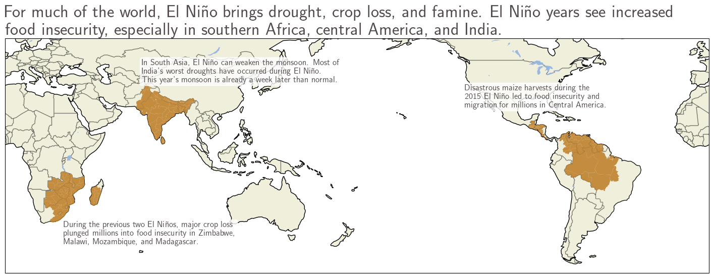
While El Niño brings heavy rainfall to some regions, it brings drought, famine, and crop failure to many others. El Niño greatly influences agricultural production in the tropics – during El Niño years, global grain production in the tropics can drop by as much as 3%. El Niño is influential for nearly 30% of global croplands, and the strong El Niño of 1982 - 1983 has been blamed for the largest global crop failure in modern history. The World Bank has already warned that food insecurity will likely continue to increase this year, as an El Niño comes on top of rising oil, gas, and fertilizer prices. And as the climate warms, harvests of crops like maize could become even more variable, further increasing the risk of widespread crop failure during future El Niños.
El Niño weakens the Indian monsoon, leading to drought, crop failure, and food insecurity. In India and South Asia, El Niño is typically associated with a below-average monsoon. A below-average monsoon can be devastating for South Asia – the summer rains bring 75 - 90% of the year’s rain for much of the region, and a shortage of rainfall can lead to crop failure, food insecurity, and a lack of drinking water.
In India, climate change is already increasing the risk of crop failure, as El Niño years in a warmer climate could put millions at risk of famine. Furthermore, during El Niño, the rains that do fall are likely to be even more extreme, exposing more people to hazardous conditions like flash flooding and landslides. While an El Niño is not a guarantee of a weaker monsoon, the Indian Meteorological Department has predicted a below-average monsoon season for 2026, and the monsoon rains are already behind schedule.
El Niño years see dry conditions and risk of famine in Central America and northern South America. In Central America and northern South America, El Niño means drought, famine, and intense heat. The Central American Dry Corridor, which includes Guatemala, El Salvador, Nicaragua, and Honduras, is particularly vulnerable to food insecurity during El Niño, during the 2015 - 2016 El Niño, drought and disastrous maize harvests put 3.5 million people at risk of famine. Climate change has already intensified drought in this region, and further warming could further decimate crop yields and ultimately displace up to 2 million by 2050. El Niños could further exacerbate these future conditions, leaving even more people displaced or suffering from food insecurity.
El Niño is a major driver of drought and famine in southern Africa. Across southern Africa, El Niño years are often accompanied by widespread drought, leading to crop shortfalls and food insecurity. Southern Africa’s crop production is more impacted by a strong El Niño than anywhere else on the planet, leaving the region particularly vulnerable to crop failure and food insecurity. The 2015 - 2016 and 2023 - 2024 El Niños saw major decreases in grain production in southern Africa, leading to food insecurity and famine for millions. The World Food Programme is preparing for heightened food insecurity in southern Africa and Latin America, with the hope that early warning systems will reduce the impacts of El Niño.
Smoke and Heat: El Niño's Wildfire Regions
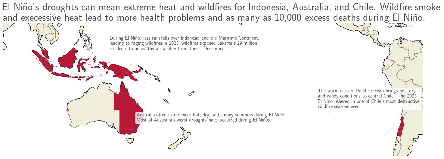
El Niño makes Australia’s summers hotter, drier, and smokier. In Australia, El Niño years are associated with hot, dry summers, especially in northern and eastern Australia. Historically, most of Australia’s largest droughts occur during El Niños, and El Niño brings hot summer days and elevated bushfire risk for Australia’s populous southeastern states. That said, a stronger El Niño is not a guarantee of a larger impact for Australia– the strong 1997 - 1998 El Niño did little to increase drought in Australia, while a substantially worse drought and crop failure occurred during the much weaker 2002 - 2003 El Niño. While summer’s impacts will not be known for months in Australia, Australia’s Bureau of Meteorology has already predicted a dry spring and early winter for much of the country, especially Queensland and New South Wales.
Wildfires rage in Indonesia and Chile during El Niño years. During El Niño years, the rains that usually fall on Indonesia shift eastward over the unusually warm waters of the Pacific Ocean. These dry conditions increase wildfire risk during El Niño years. Two of Indonesia’s largest fire seasons occurred during El Niño: in 2023, fires burned 5 times more area than the previous year, exposing millions to unhealthy air quality for 7 months. During El Niño years, it’s estimated that heightened wildfire smoke exposure causes an additional 10,000 deaths in Indonesia and southeast Asia. Indonesia’s wildfire risk is expected to rise with climate change, making future El Niños even more deadly.
Across the ocean, El Niño also raises wildfire risk in central Chile. The warm temperatures in the East Pacific ocean lead to hotter, drier, and windier conditions in central Chile, increasing the risk of catastrophic wildfires. The 2023 wildfire season was one of Chile’s most destructive ever. Chile’s fire risk is already increasing due to increases in climate-driven drought and heatwaves; El Niño years act to compound that fire risk.
The Jupiter modeling approach is deliberately rigorous. Our projections include robust uncertainty estimates spanning the 5th and 95th percentiles of outcomes, drawn from dozens of simulations run by over 20 climate models — ensuring our projections represent the full range of plausible outcomes, including the impacts of El Niño and La Niña.
Our generative modeling products go further, providing additional multivariate climate realizations for specified locations by training diffusion models on GCM and reanalysis data to create synthetic time series of daily climate variables such as rainfall, winds, and temperature.
And they go further still: where most climate models lack ensemble sizes large enough to accurately model extreme events, Jupiter's generative approach can provide a user with 50 different simulations of rainfall over Los Angeles, Porto Alegre, or Nairobi from 2026 to 2050 — making it virtually certain that the full range of El Niño impacts is captured.
El Niño in a Warmer World: What Science Does (and Doesn't) Know
The future of the El Niño - Southern Oscillation (ENSO) has been of great interest to scientists, with thousands of scientific papers published on this topic. However, even with state of the art climate models, scientists are still not sure what ENSO will look like in a warmer world. Global climate models, limited by spatial resolution, sparse observations, and complex ocean dynamics, struggle to simulate certain aspects of ENSO.
Currently, some scientists predict that strong El Niño events could become more common in the future, but scientific consensus is so far elusive. Even less is understood about the changes in ENSO’s impacts on farther regions – for example, how El Niño’s impacts on North America could change in a warmer climate.
A clue may lie in the most recent 2023 - 2024 El Niño. This El Niño was one of the strongest on record, but its impacts on North America were limited. Scientists hypothesize that extremely warm temperatures in the Atlantic and Indian Oceans, driven by anthropogenic warming, counteracted the usual impacts of El Niño. If these regions continue to warm faster than the tropical Pacific Ocean, El Niño’s impacts on far-away regions like North America could be dampened.
Is El Niño Shifting Us Into a Warmer World?
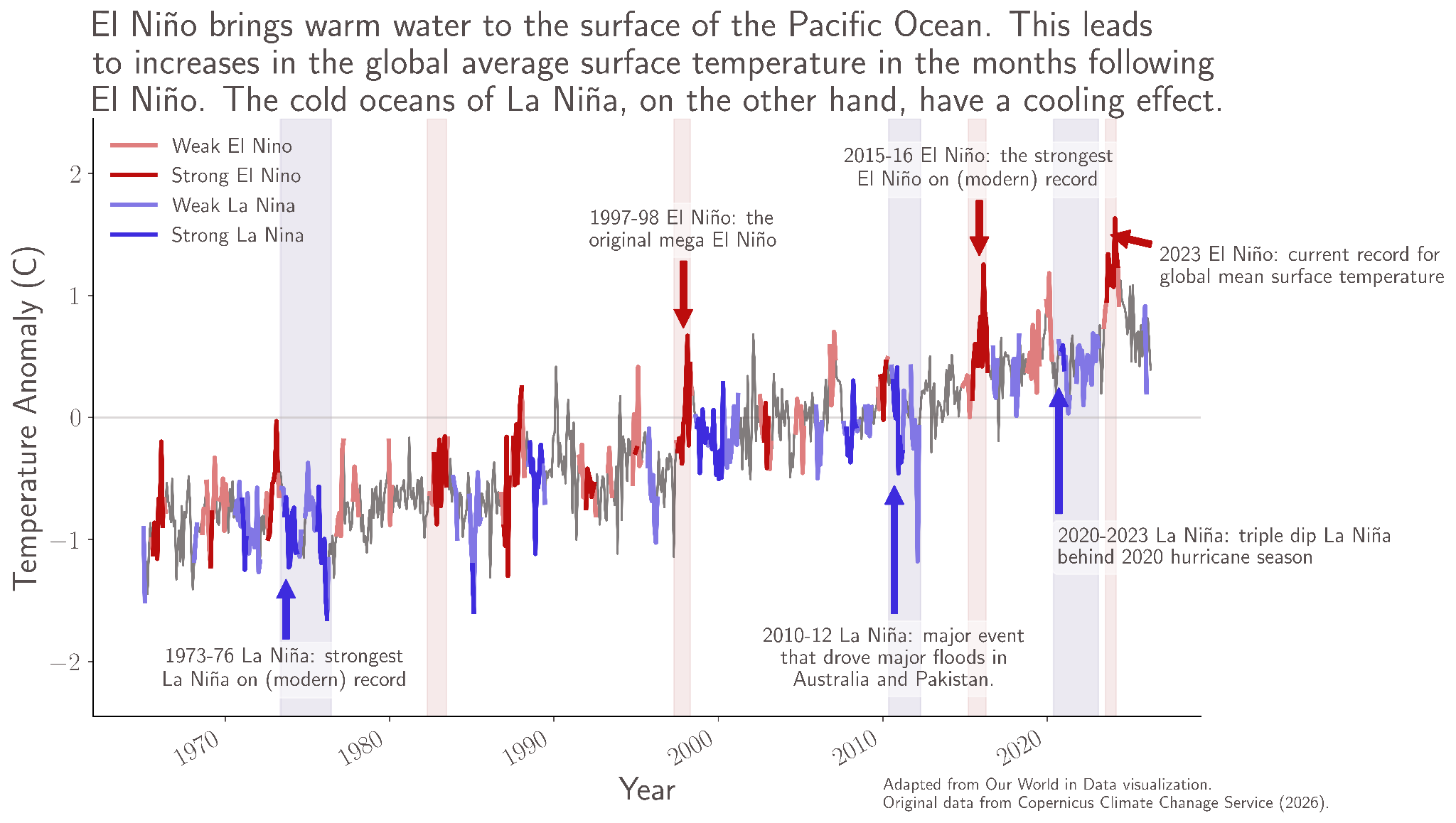
The globe is hotter during El Niño years than neutral or La Niña years. Many meteorologists and climate scientists have predicted that 2027 will set a new record for the hottest year ever – last broken during 2023’s El Niño. El Niños may be “climate shocks”, leading to irreversible change. In 2015, El Niño brought the globe to 1°C above normal for the first time – and we’ve never come back below that.
This year’s El Niño could push the global mean surface temperature in 2027 up to 1.7°C above normal. And even after the El Niño fades, the Earth could remain as much as 1.5°C higher than normal, already exceeding the goal laid out by the Paris Agreement.
Ultimately, we will have to watch the impacts of El Niño unfold over the coming months. While we don’t know exactly what the impacts will be, El Niño is likely to bring heat, drought, warm oceans, and heavy rains to much of the globe, and it may bring us the hottest year ever in 2027.
El Niño is a reminder that Earth’s climate system operates on its own timeline, indifferent to fiscal years, supply chains, or infrastructure replacement cycles. Its impacts will unfold over the coming months across dozens of countries, affecting agriculture, energy demand, water supply, and storm risk simultaneously. In a warming world, each successive El Niño arrives into conditions that amplify what it can do. Quantifying that risk is no longer optional for organizations with long-term exposure to climate. And understanding that shift — not just that El Niño has arrived, but what it means in a climate that has already moved — is the work that separates preparation from reaction.
This article is part of the Jupiter Research initiative, where our scientists and risk experts explore the climate forces shaping tomorrow's risks. Learn how Jupiter helps organizations quantify uncertainty, evaluate future scenarios, and make more resilient decisions in a changing climate. Contact us here.
