.webp)
Summer 2026: A Perfect Firestorm
In July, an extremely hot and dry summer for Western Europe gave way to another hazard: wildfire. Week after week of relentless heat and little rainfall created ecosystems that were ready to burn across Spain and France. During the week of 23 - 30 July, over 300,000 people were evacuated from several large wildfires outside of the major metro areas of Madrid and Bordeaux. Since then, nearly 400,000 hectares (over 970,000 acres) have burned across France and Spain as of 9 September. Increased warming has made the extreme fire weather conditions that preceded this wildfire outbreak an estimated 20 times more likely.
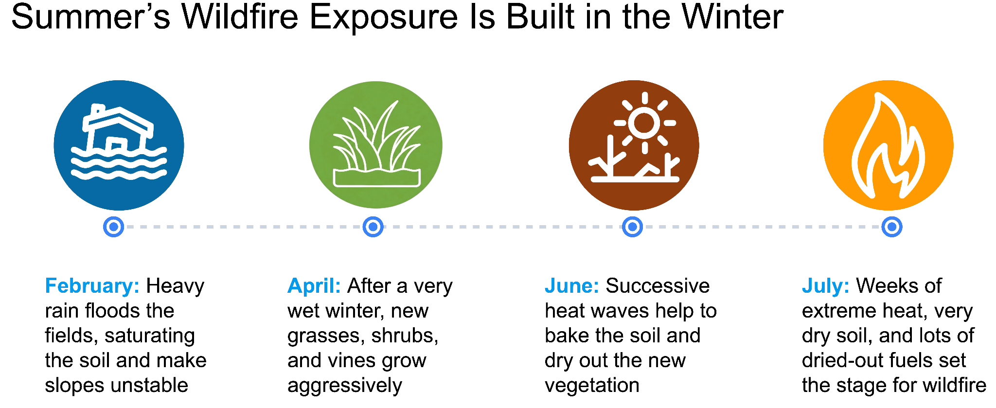
Such a precarious situation is rarely built in a single day, or even a week. The massive wildfire outbreaks in Spain and France started in July, but the foundation for such an extreme event was laid during the winter. Spain and France both experienced some of their wettest winters in years, meaning that by spring, new plant growth was aggressive and abundant. But a hot, dry summer turned a green, dewy spring into a parched tinderbox in waiting.
Winter 2025 - 2026 was the wettest in decades for much of western Europe, with many countries having a much higher than normal number of rainy days. Spain experienced its wettest winter in 25 years. In France, it rained every single day between 13 January and 22 February, and the country’s wettest February ever led to historic flooding on the Loire, Maine, Garonne, and Charentes Rivers. The heavy rains allowed vegetation to flourish, with above-average shrub, grass, and crop growth throughout the spring. But as the summer started, extreme heat and low rainfall created a dangerous wildfire situation for western Europe.
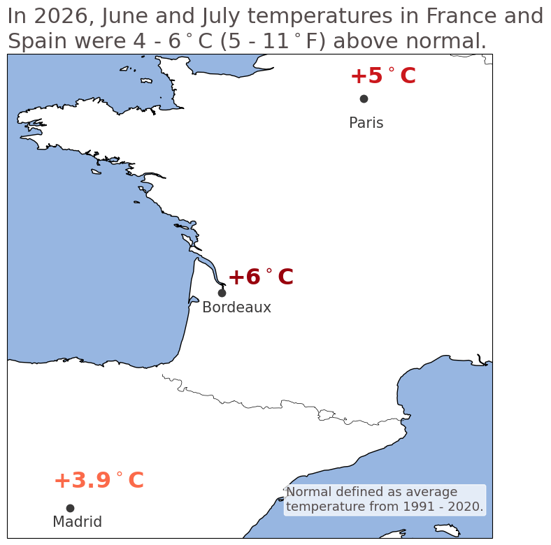
June and July 2026 were the warmest-ever for western Europe. Every major city in France was an average of at least 2.8°C (5°F) warmer than the 1991 - 2020 average, and many cities in the north and west were much warmer than that. Paris was an average of 5°C (9°F) warmer than normal, and Bordeaux’s temperatures were a staggering 6°C (11°F) above average. Spain, especially northern and central Spain, was also very warm, with Madrid averaging nearly 4°C (7°F) above average.
Soaring daily high temperatures, several prolonged heatwaves, and a lack of rainfall meant that the spring’s abundant vegetation dried out quickly. By mid-July, drought warnings covered most of France, and dry conditions expanded across western Europe, reinforced by extreme heat. Amid nearly 3 months of heatwaves and low rainfall, any small ignition event could lead to disaster.
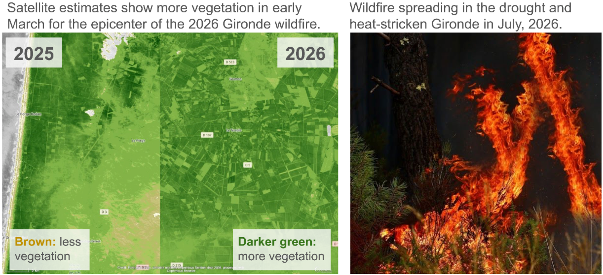
By 19 July, fire took hold in the Sierra Norte de Guadalajara natural park, northeast of Madrid. Hot, dry, windy conditions helped this fire spread, and more fires started in the following days. By 22 July, new fires erupted near Navaluenga, in the Ávila province, and Navas del Rey, a mountain town outside of Madrid. These fires quickly merged to form the largest wildfire in Spain’s history. At the same time in France, a wildfire started and quickly spread outside of Le Porge, to the west of Bordeaux.
In the days that followed, over 300,000 people were evacuated in central Spain and southwest France. Fires have destroyed over 200 homes in France, and damaged many more. Nearby cities have suffered from repeated hazardous air quality episodes due to wildfire smoke–Bordeaux’s air quality has been 20x worse than the acceptable standard, while nearly 100,000 people in the Madrid area were asked to remain at home for several days to avoid wildfire smoke exposure. Cities as far as Limoges, 400 km from Bordeaux, experienced periods of extremely poor air quality.
2026 has been France’s worst-ever fire season, with almost 100,000 hectares (nearly 250,000 acres) consumed by wildfire; and Spain’s second worst. Across the European Union, wildfires have burned about twice as much area in 2026 as the 2006 - 2025 average, although 2026 has thus far burned less than 2025. Through September 2, burned area is twice the 2006 - 2025 average, and CO2 emissions are 47% higher than normal. And while these wildfires are mostly contained as of early September, the wildfire season is not over yet. In Spain, about 20% of large wildfires start in September and October.
“Did your model predict this”? Exploring Jupiter’s wildfire model in the Madrid and Bordeaux wildfires
Introducing the Jupiter Wildfire Model
The Jupiter wildfire model is built with global climate model data, reanalysis, and satellite-derived estimates of wildfire probability and land coverage. The Jupiter wildfire model uses machine learning to create a high-resolution wildfire model from lower-resolution datasets, like ERA5 reanalysis and global climate model data. Jupiter’s wildfire model was trained on global satellite estimates of wildfire activity from 1997 - 2016. The wildfire model skillfully identified high wildfire risk areas in the U.S. and Europe, noting that areas that have burned between 2017 - 2025 had a 150 - 250% higher wildfire probability than areas that did not burn (see this post for a more in-depth look at Jupiter’s wildfire model).
The wildfire perimeters for wildfires in Spain and France are defined using the European Forest Fire Information System (EFFIS) daily burned area estimates. Different scientific agencies can provide slightly different estimates of wildfire perimeters, especially for real-time estimates. To account for this, we apply a small 5 km buffer around each wildfire’s perimeter. Provincial boundaries were obtained from the Humanitarian Data Exchange, and metro area boundaries were obtained from the Eurostat/GISCO Urban Audit 2024 dataset.
Madrid: Wildfires Erupt in High-Risk Mountain Wilderness
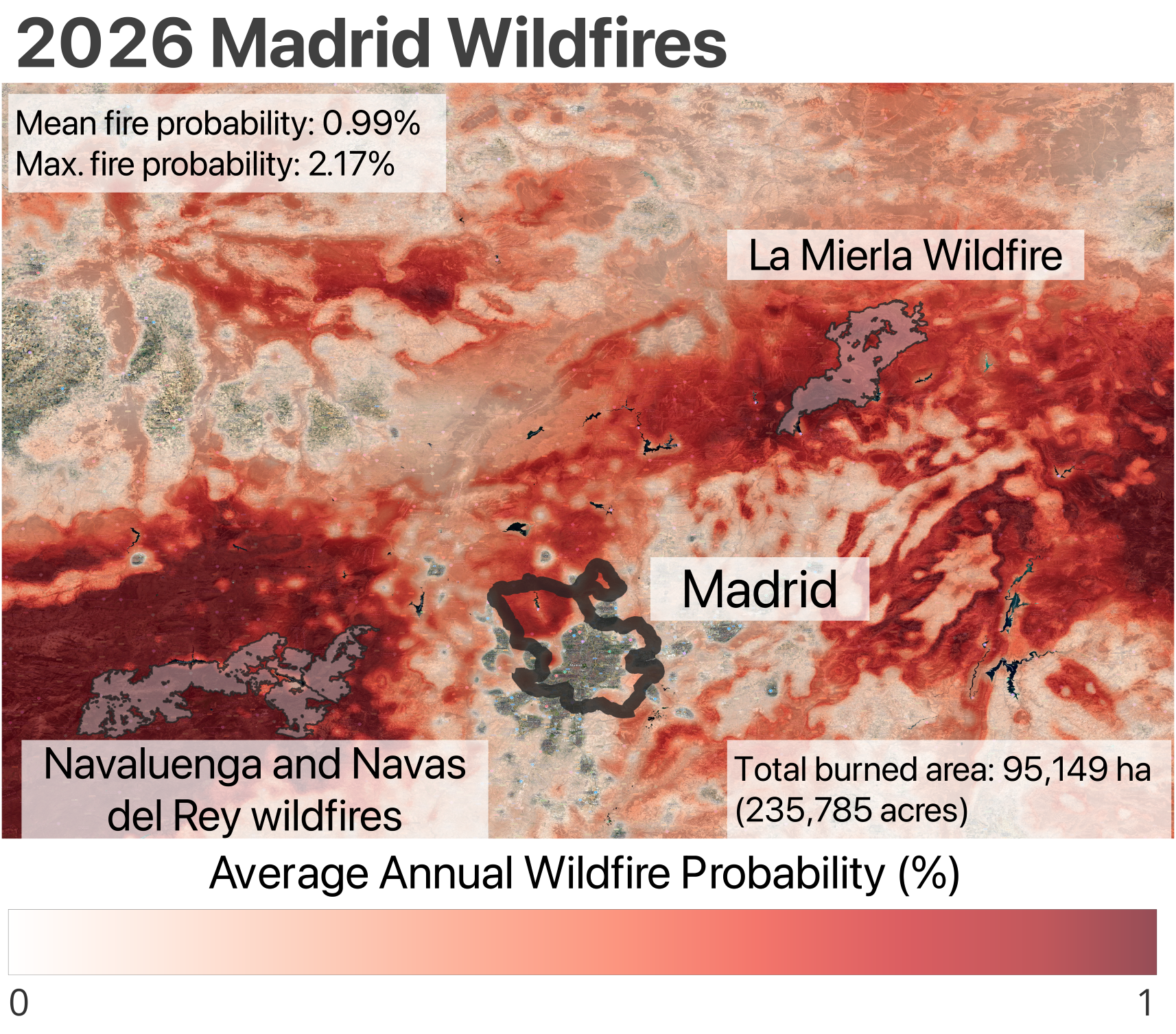
Jupiter’s wildfire model identifies much of the area around Madrid as having a high wildfire risk. In Ávila, west of Madrid, the Navaluenga and Navas del Rey wildfires merged into a single blaze, while the La Mierla wildfire raged in Guadalajara, northeast of Madrid. Within the perimeters of these wildfires, the average wildfire probability was 0.99%, signifying high fire risk throughout the burned area. An average annual wildfire probability of 1% means that across the regions currently burning in central Spain, a catastrophic wildfire is a 1-in-100-year event in the present day. Within this year’s wildfires, the highest wildfire probability was over 2%--meaning that catastrophic wildfire is less than a 1-in-50-year event for some locations.
In short, the Madrid wildfires burned in areas that the Jupiter wildfire model correctly identified as having a high wildfire risk.
Bordeaux: Extreme Heat Makes Tail Risk More Likely
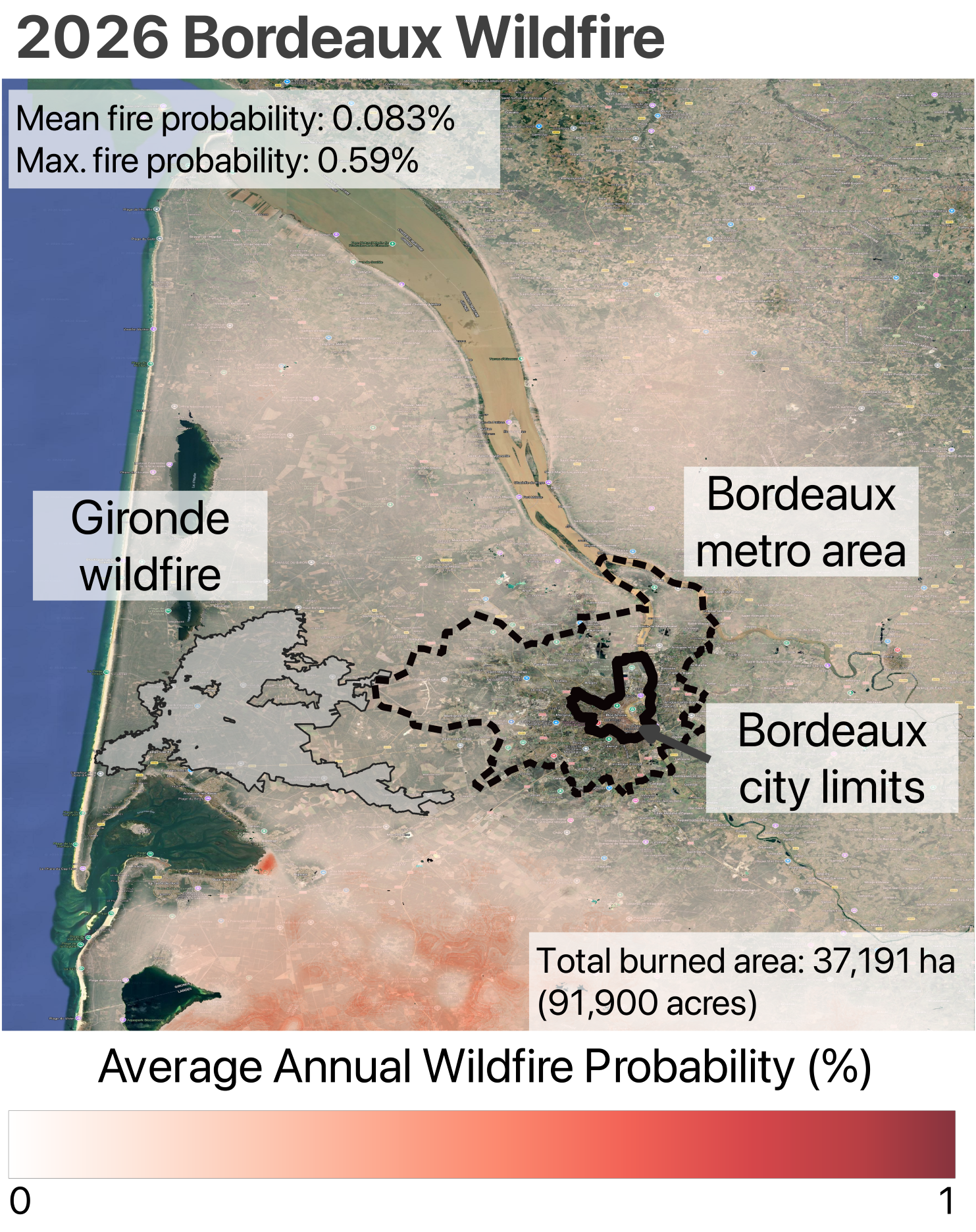
While wildfire risk is high in central Spain, the picture outside of Bordeaux is more complex. Southwest of the Bordeaux metro area, the Landes forest in the Landes de Gascogne natural park is correctly identified as a high-risk area (in fact, this forest was the site of France’s largest-ever wildfire in 1949). But the 2026 wildfire started to the north of this forest. In fact, Jupiter’s model estimates that the average wildfire risk across the area that burned this summer is less than 0.1%.
While the average wildfire probability across the burned area is low, the peak wildfire probability within this summer’s fire is much higher–just under 0.6%, corresponding to a 1-in-165-year event. So while the majority of the 2026 Gironde wildfire has a lower wildfire probability, some locations do have much higher wildfire risk.
“How did a fire start in a ‘lower-risk’ area”? Making Sense of a Seemingly Unlikely Result in Bordeaux
Looking at Figure 4, it’s reasonable to ask the question, “How did such a large wildfire start and spread in an area that’s marked as ‘lower risk’?” The Jupiter science team had the same questions. When the team dove into these wildfire model results, we identified several key factors that explain what may appear to be an unintuitive result.
Bordeaux did not face typical conditions in summer 2026. Despite this year’s wildfire a lower average annual wildfire probability in Jupiter’s wildfire model, the situation in Bordeaux was far from “low risk” this year. France’s summertime temperatures were exceptionally hot by any definition. This was especially true for Bordeaux and the southwest, where daily high temperatures were an average of 6°C (11°F) higher than normal. France was also plagued with a succession of heatwaves, some of which were so extreme as to be 1-in-1000 year events. Beyond the extreme heat, summer 2026 was one of the driest on record for France. In short, wildfire conditions were extreme in southwestern France.
Furthermore, it is worth remembering that low risk is not the same as no risk. While catastrophic wildfires are more likely in high-risk areas, fire can start, and spread, in areas with lower background risk. Within the Gironde wildfire, there were locations for which a wildfire was a 1 in 165 year event–not especially rare, especially in such an extreme summer. And many locations very close to the fire, which happened not to burn this year, have similar or even higher fire risk. We caution against the assumption that the whole region is “low risk”, or that wildfire risk models are flawed, just because this year’s fire happened to start in an area with a lower average annual wildfire risk.
Finally, wildfire ignition is ultimately a random event–especially when humans, who start an estimated 90% of wildfires in Europe, are involved. Indeed, the Gironde wildfire may have been started by utility workers using faulty machinery. Some of the human elements of wildfire risk may ultimately be able to be managed or reduced with guidance and regulation for industries like utilities and construction. But other aspects of human behavior will be difficult if not impossible to model.
Fire risk in southwest France may be underestimated. Wildfire risk in western France has consistently been challenging to model. Many studies have found that existing modeling frameworks consistently underestimate wildfire risk in western France. A study of the 2022 wildfire outbreak in southwest France found that existing models underestimated wildfire risk, and a rapid attribution study of this year’s wildfires came to a similar conclusion. Wildfire experts have also found that future wildfire risk projections are more uncertain for western France than for many other regions in Europe and elsewhere.
Part of the reason that modeling wildfire risk in western France is so challenging is that existing research is somewhat skewed towards North America. Historically, the U.S. and Canada have dominated wildfire research, and many of the existing modeling approaches and metrics were developed in North America. When models trained on North America are extrapolated, we implicitly assume that the rest of the world behaves similarly. In many cases, it does–the Jupiter wildfire model, for example, is trained on a U.S.-based dataset, but skillfully identifies wildfire risk outside of the U.S. But in western France, these assumptions are challenged. Specifically, western France has a relatively high fraction of croplands (about 37% in Gironde), and a fairly high annual rainfall–850 mm (33 inches) per year, including consistent rain during the summer. In North America, a region with similar characteristics would have relatively low wildfire risk–but this is not the reality for western France due, in part, to differences in agricultural tradition and the role of long-term drought.
France’s unique agricultural practices may contribute to modeling challenges. Unlike many other countries (including the U.S., Canada, and Spain), French agriculture uses very little irrigation. This is especially true for wine grapes–the largest crop in the Gironde. Irrigation is actually banned from 1 May until harvest for any wines produced in a French Appellation d’Origine Contrôlée–a designation that includes nearly all vineyards in the Gironde. In most years, vineyards receive enough rainfall that supplemental irrigation is unnecessary, but in years like 2026, the extreme heat and lack of rainfall can dry out fuels and increase fire risk.
Finally, long-term drought may be critical for wildfire risk in western France. Longer-term drought has been shown to be an important predictor for wildfire risk in this part of France, but current methods have shortcomings in how drought is represented. This year may provide some key insights, as Bordeaux has had 49% less rainfall than average from March - July, 2026.
Improving wildfire risk modeling in western France may improve other regions. Western France provides a different wildfire risk environment than seen in much of North America or the Mediterranean. These traits that make western France different–high fraction of cropland, low prevalence of irrigation, and higher rainfall–can be found elsewhere in western Europe. This summer, Belgium experienced a wildfire of greater than 3000 hectare blaze (approximately 7413 acres)–its largest in over a century. The fire broke out in the High Fens Nature Reserve–a natural park that is watered only by precipitation. The High Fens are typically one of the wettest, coldest parts of Belgium. But in a summer like 2026, extreme heat and little rainfall can turn a damp bog into a fire hazard.
Understanding Future Wildfire Risk for Madrid and Bordeaux
Madrid: Hotter Summers Increase Wildfire Risk in an Already At-Risk Area
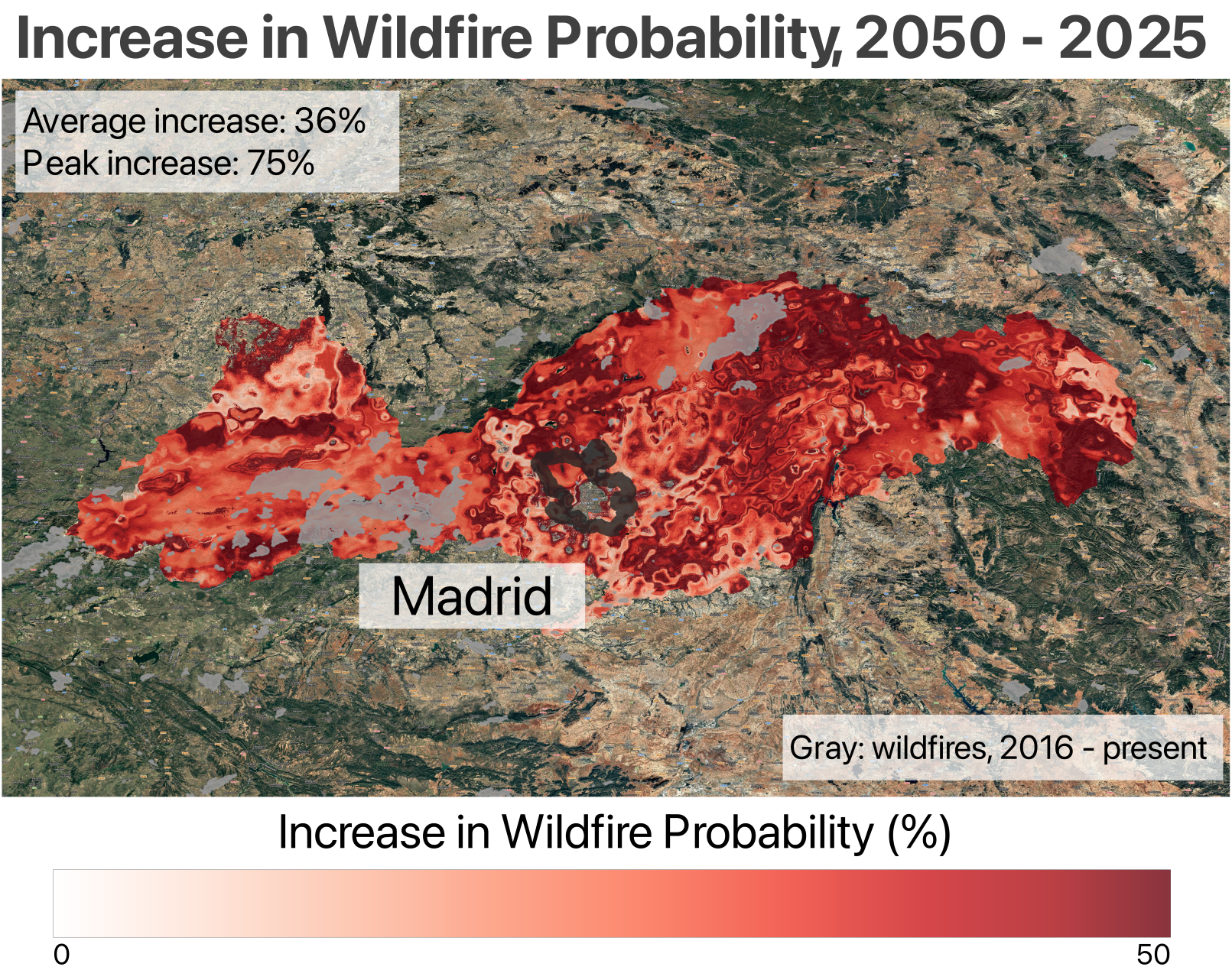
Summers in Spain’s capital are already hot and dry, and Jupiter models predict they will get hotter and drier by 2050. In and around Madrid, summer days will be about 7% (2°C, or 3.5°F) hotter, and heatwave days (defined as 3 or more consecutive hot days) will be about 200% more common than the present. The hot, dry summers mean wildfire risk is already high–much of central Spain already has an average annual wildfire probability of 1% or more. But the area around central Madrid will see its wildfire risk rise. Across Ávila, Guadalajara, and the Comunidad de Madrid, Jupiter models estimate that average annual wildfire probability increases by 36% by 2050, with increases reaching 75% in some areas.
Bordeaux: Hotter, Drier Summers Drive Wildfire Risk Up
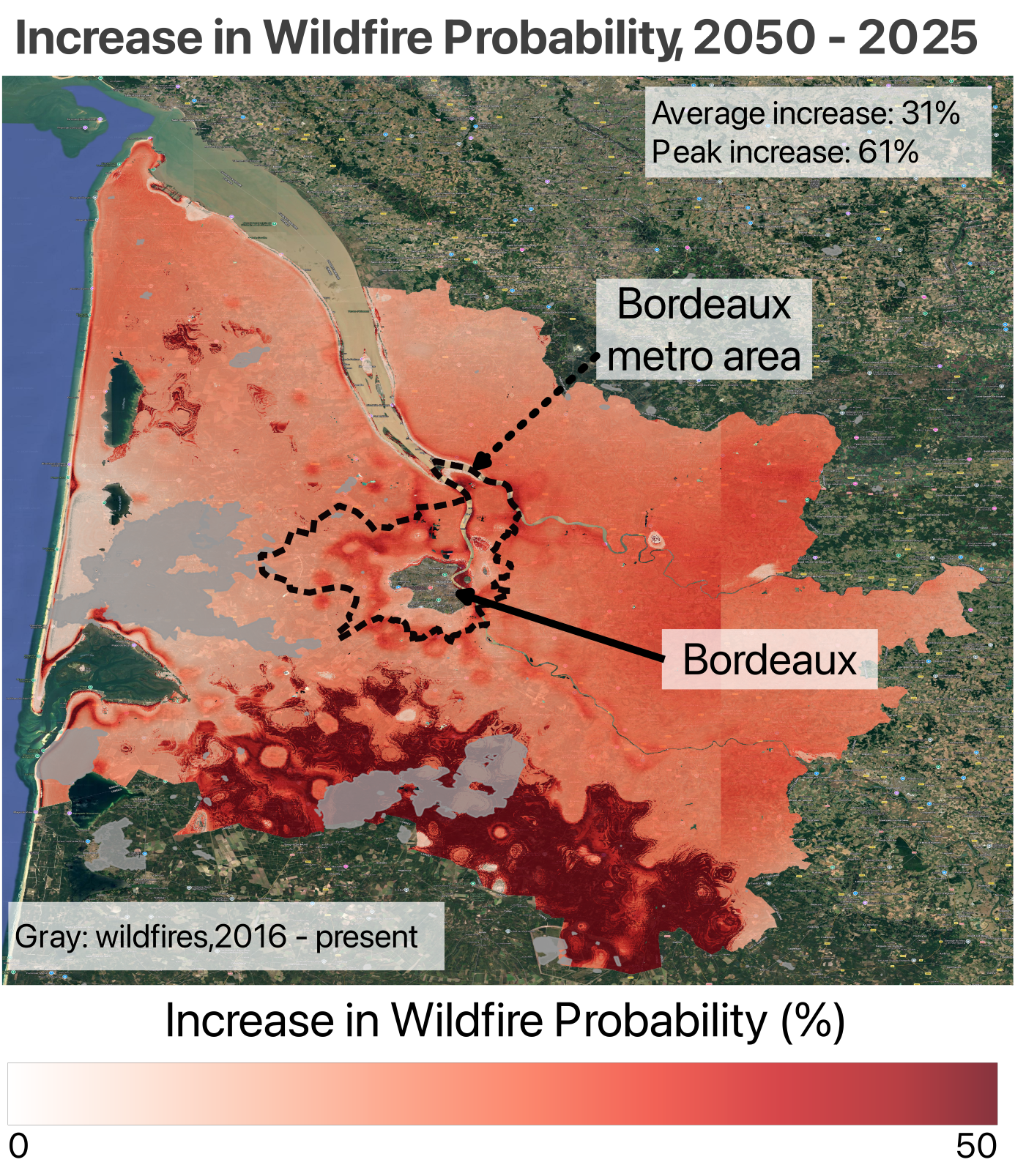
In the Gironde départment, Jupiter models expect about 4% less rainfall throughout the year by 2050, with as much as 18% less rainfall in the summer months. Jupiter models also predict that by 2050, the average summer day in and around Bordeaux will be about 5% hotter (about 1°C, or 1.8°F), and heatwave days could increase by as much as 250%. Consequently, Jupiter wildfire models expect that average annual wildfire probability will increase by 31% across the Gironde départment by 2050, and localized increases could exceed 60%. For much of the Landes forest, south of Bordeaux, average annual wildfire risk approaches 1% by 2050.
Emerging Risk: Northern Spain and Central France
Spain is often thought of as hot and dry, and many of Spain’s highest wildfire risk can be found in southern Spain. But some of the biggest increases in wildfire risk are actually on the northern plains, and along the rainy Atlantic coast in the region known as “green Spain”. These areas, including Galicia, the Basque Country, and Castile and León, are projected to see some of the biggest increases in summertime temperatures and heatwave days. And while Spain is projected to get drier overall, wintertime precipitation is not expected to change much for this part of Spain. In fact, wet winters may precede many of Spain’s largest wildfire outbreaks.
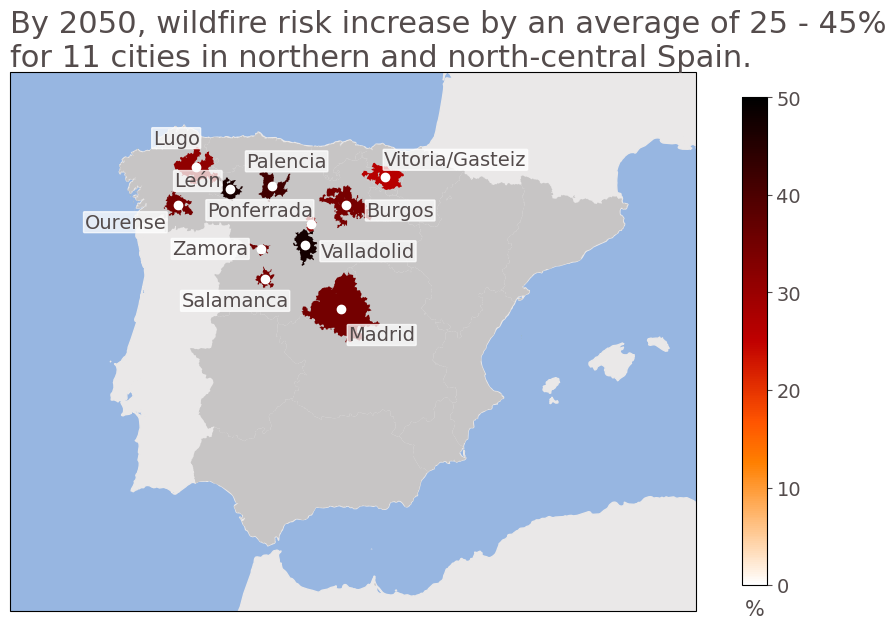
We estimated the change in wildfire risk from 2025 to 2050 for all Spanish metro areas over 100,000 people. We find that 11 of the 20 cities with the greatest increase in wildfire risk are in the northern provinces of Galicia, the Basque Country, Castile and León, and Madrid; and 5 of the 20 highest-risk cities can be found in the wettest area of Spain. For example, in the Galician city of Ourense, wildfire risk increases by 35% on average between 2025 and 2050. Ourense’s highest-risk areas see their wildfire risk increase by nearly 50% by 2050.
Similarly, the French cities with the highest overall wildfire risk in the present and in 2050 are near the Mediterranean–cities such as Perpignan, Montpellier, and Marseille. But as in Spain, the greatest increases in wildfire exposure in the next 25 years are not in the French cities that face the greatest risk today.
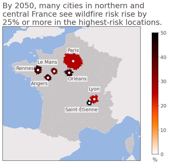
We estimate wildfire risk for every metropolitan area in metropolitan France with a population of at least 100,000. In France, the difference between the mean and highest wildfire probability across a metro area can be quite large, so we focus on the peak wildfire probability in a metro area for an estimate of the highest-risk section. We find that many of the largest wildfire risk increases in the next 25 years are in central and northern France. Cities like Saint-Étienne, Lyon, Orléans, Rennes, Angers, Le Mans, and even Paris see wildfire probability increase by 25 - 55% in their highest-risk areas. In Lyon and nearby cities like Saint-Étienne, catastrophic wildfire could become nearly a 1-in-200 year event by 2050.
In these French cities, the increases in wildfire risk are driven primarily by hotter, drier summers with large increases in heatwave days. These cities see average summer temperatures increase by 5 - 6% by 2050. Heatwave days, which can be major contributors to creating dangerous wildfire conditions, are projected to increase by 200 - 300%, and summer rainfall is projected to decrease by 12 - 15%. Thus, as summers get hotter and drier in northern and central France, rising wildfire risk could threaten major cities.
Compounding Impacts of Heat and Drought
The compounding nature of extreme heat, drought, and wildfire hazards means that extremes can build upon each other. Extreme heat, especially consecutive heatwave days, can make drought even worse by increasing evaporation. A lack of rainfall worsens extreme heat, as rainfall can provide cloud cover and relief. And extreme heat and drought build the hot, dry conditions that raise wildfire risk.
Summer 2026 emphasizes how much heat and drought have already affected wildfire risk. Western Europe experienced several major heatwaves between May and August–heatwaves that could have been 2°C cooler just 20 years ago. Warming has already made western Europe’s drought 5 times more likely, and shifted drought thresholds. In a cooler climate, a summer with as little rainfall as this one would likely have resulted in a ‘moderate’ drought instead of a ‘severe’ one. But as increased heat increases potential evapotranspiration, plants, soils, and bodies of water dry out much faster. Intense drought conditions, like those of this summer, could become up to 10 times more likely in western Europe in the future.
Europe has invested in wildfire management, but the economic impact of wildfire is growing quickly.
In the last 5 years, the European Union has greatly strengthened its wildfire prevention and response. The EU has tripled the number of international firefighters, who can be deployed across the EU as needed, and allocated €1 billion ($1.15 million) to fire management. Investing in wildfire prevention and management is prudent–improvements in fire management can help to limit burned area, helping to offset rising wildfire risk. But fires have burned more forest than ever, and extreme fire weather days have doubled since the 1980s in much of Europe, including France and Spain. Even with ideal management, fire activity will likely continue to rise in over half of Europe’s fire-prone areas–and may spread to areas previously considered low risk.
But wildfires are getting costlier every year. Munich Re estimates that global wildfire losses from 1980 - 2025 have totalled $290 billion (€250 billion)--with much of the total coming from the last decade. Historically, wildfire-related losses in Europe have been relatively modest–Spain’s 2025 wildfires, the worst in the country’s history, generated just 900 claims, and €23 million ($26.7 billion) in insured losses. Less than €10 billion ($11.5 billion) of the €173 billion ($200 billion) in global wildfire losses between 2016 - 2025 came from Europe. But increases in extreme heat, drought, and fire weather for Europe mean that future risk is likely rising quickly–and historical risk may not be an adequate predictor. In the past decade, wildfires have gotten far more economically disastrous–and this fire disaster risk is highest in economically well-off regions, including Europe.
In the European Union, only 10% of heat, drought, and wildfire losses are insured, highlighting a massive protection gap. And while Europe is spending an average of €29 billion ($33.5 billion) per year on adaptation, the recommended spending of €70 billion ($81 billion) per year is more than double. With climate-related damages totalling an estimated €45 billion ($52 billion) per year, climate disasters are already costing Europe billions. As early as 2030, France and Spain could experience 5 - 7% reductions in economic growth due to the combined impacts of heat, drought, and wildfire.
Beyond financial risks, the health risks of wildfire smoke exposure continue to climb for western Europe. Deaths attributed to wildfire smoke have been rising in Western Europe, and extreme heat can further amplify the health impacts of wildfire smoke. Extreme heat and wildfire smoke exposure both strain the healthcare system, causing further stress on a stretched resource.
Preparing for the future: lessons learned from the 2026 wildfires
This summer’s wildfire outbreaks around Madrid and Bordeaux impacted over 300,000 people. A wet winter, followed by an exceptionally hot summer created new vegetation that was dried out and ready to burn. While Madrid and its surroundings are correctly identified as having high wildfire risk, much of the area outside of Bordeaux did not have particularly high wildfire risk. But upon a closer look, the factors behind this year’s fire outbreak became more clear:
- Southwestern France faced particularly extreme conditions during summer 2026;
- The “wet agricultural” environment of southwest France has low fire risk in the U.S.-based training data, but this relationship does not hold for France;
- Wildfire risk modeling is especially challenging in western France due to the importance of long-term drought and unique agricultural practices.
In the next 25 years, some of the biggest increases in wildfire risk in France and Spain are not in the areas with the highest present-day risk. We identify 11 metro areas in northern and north-central Spain, and 7 in northern and central France as hotspots of emerging wildfire risk.
In some ways, this summer was a real worst-case scenario–extreme heat day after day, punctuated by 1-in-1000 year heatwaves, and a 1-in-50 year drought combined to create a dangerous wildfire scenario. But these hazards are not isolated–they are compounding. Extreme heat intensifies drought; drought makes extreme heat worse; and heat and drought increase wildfire risk. Understanding the evolution of wildfire risk in western Europe requires understanding changes in extreme heat and drought risk. And as the economic and health risks of the compounding heat-drought-wildfire hazards grow in western Europe, continued investment in wildfire management, wildfire prevention and resilience, and risk management are critical.
This article is part of the Jupiter Research initiative, where our scientists and risk experts explore the climate forces shaping tomorrow's risks. Learn how Jupiter helps organizations quantify uncertainty, evaluate future scenarios, and make more resilient decisions in a changing climate. Contact us here.
References
- Nixon, S., 29 July 2026: Europe’s wildfires risk new doom loop. Euractiv. Accessed 10 September 2026.
- Copernicus Emergency Management Service. EFFIS Weekly Cumulative Burnt Areas. European Forest Fire Information System (EFFIS). Retrieved 10 September 2026.
- Barnes, C., and coauthors, 30 July 2026: Climate change increases likelihood of compounding drivers of severe wildfire conditions in France and Spain. World Weather Attribution. Accessed 10 September 2026.
- Copernicus Climate Change Service, February 2026: Precipitation, relative humidity, and soil moisture for January 2026. European Centre for Medium Range Weather Forecasts. Accessed 10 September 2026.
- France24, 24 February 2026:'A winter's worth of rain': France's record 40-day streak comes to an end. Accessed 10 September 2026.
- Copernicus Climate Change Service, July 2026: Copernicus: Record heatwave brings hottest June for western Europe during second-warmest June globally. European Centre for Medium Range Weather Forecasts. Accessed 10 September 2026.
- Toreti, A., and coauthors, 2026: Drought in Europe July 2026. EUR 40803. Publications Office of the European Union.
- Copernicus Land Monitoring Service (CLMS). Normalised Difference Vegetation Index 2020-2025 (raster 300 m), global, 10-daily. Version 3. Accessec 10 September 2026.
- Le Monde, 23 July 2026: Wildfires ravage parts of southern France, Italy and Spain. Le Monde. Accessed 10 September 2026.
- Copernicus Emergency Management Service, 20 July 2026: Wildfire in La Mierla, Spain. European Union. Accessed 10 September 2026.
- Abad Liñán, J.M., 27 July 2026: Claves de los incendios | Hectáreas quemadas, desalojos y carreteras cortadas. El País. Accessed 10 September 2026.
- Global Fire Emissions Database (n.d.). Global Fire Emissions Database (GFED).
- Jupiter Intelligence, 10 July 2026: Did Your Model See This Coming?: Jupiter's Answer for Wildfire. Accessed 10 September 2026.
- European Commission. (n.d.). European Forest Fire Information System (EFFIS). Copernicus Emergency Management Service. Accessed 10 September 2026.
- United Nations Office for the Coordination of Humanitarian Affairs. (n.d.). Humanitarian Data Exchange. Accessed 10 September 2026.
- Eurostat. (n.d.) GISCO data distribution API - Urban Audit. European Comission. Accessed 10 September 2026.
- Jupiter Intelligence, 25 June 2026: France Sets a New All-Time Heat Record During London Climate Week. Accessed 10 September 2026.
- Foucart, S., and L. Sanchez, 5 August 2026: July breaks drought and heat records in France: 'The issue of water is becoming absolutely critical'. Le Monde. Accessed 10 September 2026.
- Dijkstra, J., T. Durrant, J. San-Miguel-Ayanz, and S. Veraverbeke, 2022: Anthropogenic and Lightning Fire Incidence and Burned Area in Europe. Land, 11, 11050651.
- Niranjan, A., 23 August 2026: Pine-cone grenades and planet-baking carbon: the French fires 170 years in the making – a visual guide. The Guardian. Accessed 10 September 2026.
- Lanet, M., L. Li, and H. Le Treut, 2025: Substantial increase in wildfire danger conditions under anthropogenic climate change in Southwest France. npj Natural Hazards, 2, 70.
- Fargeon, H., and coauthors, 2026: Projections of fire danger under climate change over France: where do the greatest uncertainties lie? Climatic Change, 160, 479 - 493.
- Yang, Z., H. Al-Najjar, and J. M. Merigó, 2026: Wildfire research: A bibliometric review. Trees, Forests and People, 26, 101401.
- USDA Forest Service. (n.d.). Wildfire Risk to Communities.
- Code rural et de la pêche maritime, art. D645-5 (Fr.). Accessed via Légifrance, 10 September 2026.
- Barbero, R., and coauthors, 2019: Simulating the effects of weather and climate on large wildfires in France. Nat. Hazards Earth Syst. Sci., 19, 441-454.
- Lanet, M., L. Li, A. Ehret, S. Turquety, and H. Le Treut, 2024: Attribution of summer 2022 extreme wildfire season in Southwest France to anthropogenic climate change. npj Climate and Atmospheric Science, 7, 267.
- Servia, F., 21 August 2026: Belgian government vows new resilience plan after wildfire. Euractiv. Accessed 10 September 2026.
- Keeping, T.R., and coauthors, 2026: Attribution of the record breaking 2025 European fire season to climate change. Nat. Hazards Earth Syst. Sci., 26, 3761-3813.
- Barnes, C., and coauthors, 26 June 2026: Fossil fuel emissions have rapidly worsened European heatwaves in just a few decades. World Weather Attribution.
- Barnes, C., and coauthors, 23 July 2026: Increasingly hot Europe faces more severe droughts and growing challenges for water and land management. World Weather Attribution.
- Bergoënd, A. and F. Servia, 26 May 2026: Wildfire season arrives again: Is Europe ready this time?. Euractiv. Accessed 10 September 2026.
- Billing, M., and coauthors, 2026: Future Projections of Burned Area in Europe Highlight the Importance of Human Action. Global Change Biology, 32, e71043.
- McCarthy, J., J. Richter, S. Tyukavina, P. Potapov, and N. Harris, 2026: The Latest Data Confirms: Forest Fires Are Getting Worse. World Resources Institute. Accessed 10 September 2026.
- Feron, S., and coauthors: Major intensification of fire weather across southern Europe in recent decades. Scientific Reports, 16, 21852.
- Munich Re, April 2026: Wildfires and bushfires - Climate change increasing wildfire risk. Accessed 10 September 2026.
- Howden Re, 2 September 2026: Europe’s wildfire risk rising despite limited historical losses: Howden Re. Global Reinsurance. Accessed 10 September 2026.
- Cunningham, C.X., and coauthors, 2025: Climate-linked escalation of societally disastrous wildfires. Science, 390, 53-58.
- Soll, J., 29 July 2026: Europe’s wildfires risk new doom loop. Euractiv. Accessed 10 September 2026.
- Weise, Z., 24 August 2026: Europe must spend billions now or face mounting climate disaster costs, EU warns. POLITICO. Accessed 10 September 2026.
- Kriit, H.K., and coauthors, 2026: The 2026 Europe report of the Lancet Countdown on health and climate change: narrowing window for decisive health action. The Lancet Public Health, 11, e386-e407.
- U.S. Environmental Protection Agency. (n.d.). Co-exposure to Wildfire Smoke and Heat.
