.webp)
Key Takeaways
- Katrina-level flood events will become more common in the future: For central New Orleans, the probability of a Katrina-level flood event in any given year triples between 2025 and 2100. For the Mississippi Gulf Coast, the probability of a Katrina-level flood event will increase by a factor of 1.5-3 between 2025 and 2100.
- Floods will become more costly, even with increased defenses: For the Mississippi Gulf, flood losses steadily increase throughout the 21st century. In the New Orleans area, flood losses for smaller flood events are mitigated initially; but a Katrina-level flood event could overtop the levees in central New Orleans as early as 2065.
Katrina: A Watershed Moment in U.S. Natural Disasters
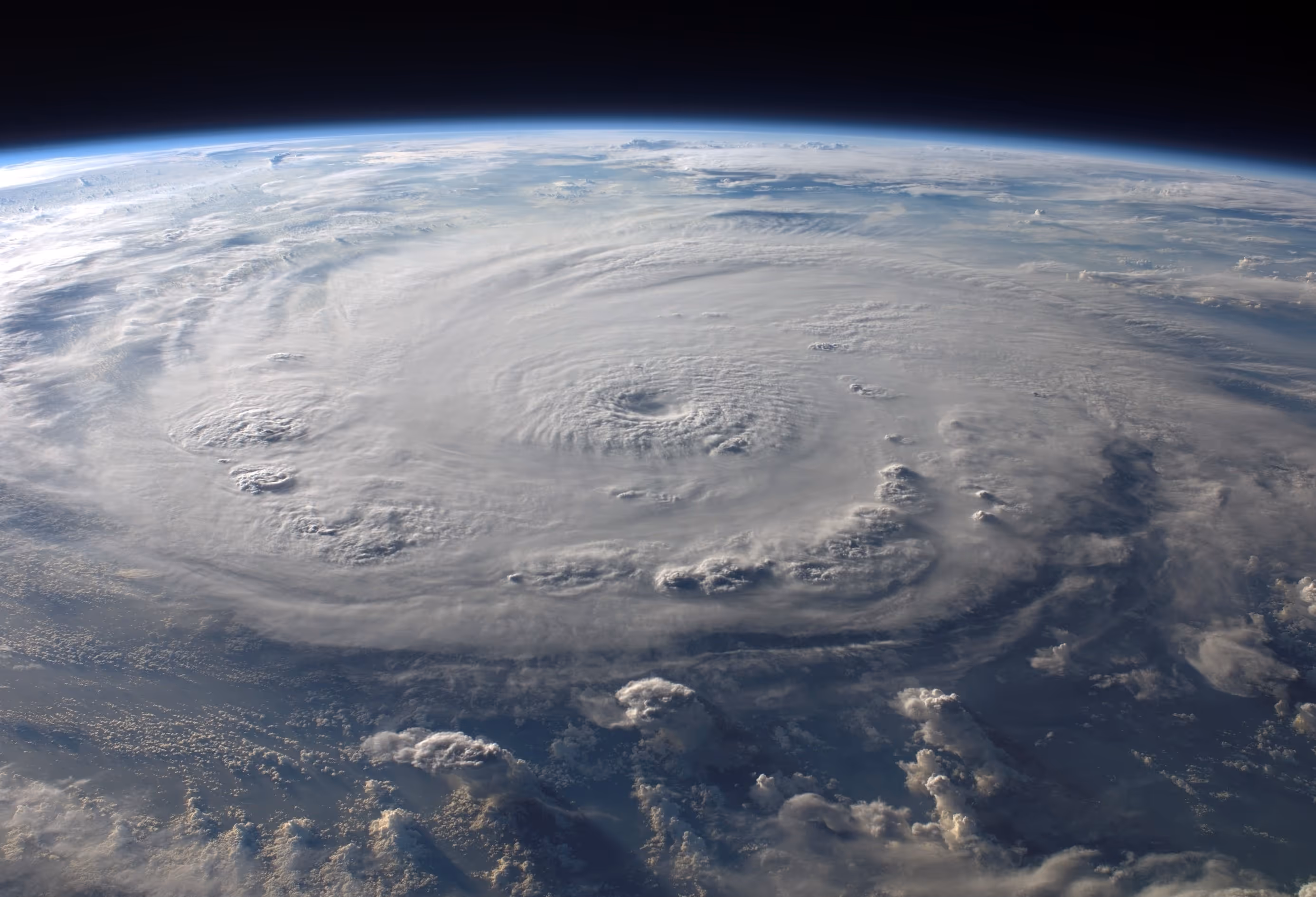
On August 29, 2005, four days after briefly making landfall in Broward County, Florida, Hurricane Katrina made landfall in Plaquemines Parish as a Category 3 hurricane. After crossing over southeastern Louisiana, Katrina briefly emerged over the ocean and made a final landfall near the Mississippi/Louisiana border. In its wake, Katrina set many infamous records some of which still stand today, including:
- Costliest U.S. Natural Disaster on Record: With an adjusted estimated cost of $201.3 billion1, Hurricane Katrina remains the costliest natural disaster to impact the United States;
- Largest Storm Surge: Katrina’s storm surge reached a record-setting 28 feet (8.5 m–a record that still stands) along the Mississippi Gulf Coast, severely impacting coastal cities like Biloxi and Gulfport2;
- Largest Diaspora Event since the Dust Bowl: Katrina caused an estimated 1.5 million Americans in Alabama, Mississippi, and Louisiana to leave their homes due to Katrina, a weather and climate-influenced population movement not seen since the 1930s Dust Bowl3;
- Second-Deadliest Hurricane since 1980: Katrina is second only to Hurricane Maria (2017) as the deadliest hurricane since modern records began in 19801.
- Costliest Event for the National Flood Insurance Plan: As of July 2025, Katrina remains the most expensive event in the history of the National Flood Insurance Plan (NFIP), as well as the event with the most claims5.
With Katrina’s help, the 2005 Atlantic hurricane season was one of the most notorious seasons on record, including:
- Most Active Atlantic Hurricane Season: With 28 named storms, 15 hurricanes, and 7 major hurricanes, 2005 is in many respects the most active hurricane season ever, challenged only by 20206;
Katrina’s devastating costs linger. In 2005, the population of New Orleans exceeded 500,000–one year after Katrina, the population had fallen by nearly half, and 20 years later, the population of New Orleans lingers around 350,000; the city has never exceeded 400,000 residents in the 20 years since Katrina. Of the 1.5 million residents of Louisiana and Misssippi who left after Hurricane Katrina, over 40% never returned. In places like St. Bernard Parish, LA, over half of the residents left after Katrina and never came back.
In a warmer world, the question is often not “will we see another major disaster?” but “when will we see another major disaster?”. Sea level rise continues to increase flood risk along the Gulf Coast, placing populations and assets at risk.
Is A Katrina-Level Event More Likely in the Future?
As sea level rises in a warming world, the risk of disastrous flooding increases in coastal locations. As tropical cyclones are expected to get stronger, with increased rainfall, flood risk can also increase due to sea level rise. Together, they create greater storm surge levels. Flood events that were once characterized as rare can become typical. Does a Katrina-level flooding event become more common in a future, warmer climate?
To explore this question, we used Jupiter Intelligence’s Climate Score Global data, which includes a Tropical Cyclone model, flood hazard models, and economic damage and loss models. It is constructed to evaluate natural hazards from extreme wind, fluvial, pluvial, and coastal flooding from surge, and especially how these risks will evolve with climate change. For this analysis, we focus on two areas–New Orleans, LA, and the Mississippi Gulf Coast. These areas were both substantially affected by Hurricane Katrina; are highly vulnerable to tropical cyclone-related hazards in the future; and contain multiple locations with long observational records. For New Orleans, we construct a portfolio using 766 assets in Orleans, Jefferson, and St. Bernard Parishes; for the Mississippi Gulf Coast, we create a portfolio using 344 assets located in the coastal counties of Hancock, Jackson, and Harrison. To estimate flooding probabilities, we first compare results from Jupiter Intelligence flood modeling to two NOAA tide stations with long observational records. Locations included in this analysis are shown in Figure 1.

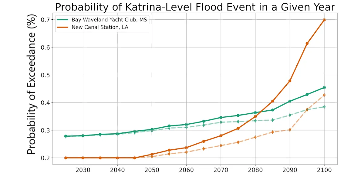
When we estimate the probability of a Katrina-level flood in future climates, Jupiter flood models predict that these events will become 1.5-3 times more likely by 2100 than they are in 2025 (Figure 2). In coastal Mississippi, a flood event of Katrina’s magnitude is 1.6 times more likely to occur at the Bay Waveland Yacht Club in 2100 than it was in 2025. In New Orleans, a Katrina-level event is over 3 times more likely to occur at New Canal Station in 2100 than it was in 2025. This 2-to-3-fold increase in the probability of a Katrina-level flood event was also seen at other Louisiana and Mississippi locations. While a Katrina-level event is still quite rare for the two locations shown above, the considerable increases in the probability of these events highlight the importance of preparing for these low-probability but high-impact events. In their 2007 report analyzing the impacts of Hurricane Katrina, the American Society of Civil Engineers (ASCE) emphasizes this point, writing that:
“The risk to New Orleanians…was much higher than many people are generally willing to accept. Because these risks were not well understood or communicated effectively to the public, the importance of evacuating people and protecting property was under-estimated.”1
Even under a moderate emissions scenario, we still see substantial increases in the probability of a Katrina-level flood event in Louisiana and Mississippi throughout the 21st century. In New Orleans, the probability of a Katrina-level flood event more than doubles by 2100 even under moderate emissions; for the Mississippi coast, the probability of a Katrina-level flood event increases by about 50%. Furthermore, the probabilities estimated from the observational tide stations are consistent across the larger New Orleans and Mississippi Gulf Coast regions outlined in Figure 1–by 2100, a Katrina-level flood event will be about 2-3 times more likely on the Mississippi Gulf Coast, and over 3 times more likely in New Orleans, as in 2025.
Katrina-Level Events Are More Likely: Will They Be More Costly?
We’ve seen that flood events that reach the storm surge levels seen during Hurricane Katrina will become more likely by 2100. Hurricane Katrina remains the costliest weather disaster in U.S. history–how will the costs of a Katrina-level flood event change in a warmer climate?
We note that damages and losses from tropical cyclones can occur from high winds and extreme precipitation as well as flooding. We focus on flooding as flooding tends to be the deadliest and costliest part of tropical cyclones–storm surge and flooding were responsible for 75% of tropical cyclone-related deaths between 1963 and 20121. During Katrina, catastrophic levee and floodwall failures submerged 80% of New Orleans in flood waters2, contributing directly and indirectly to many of the over 1,000 Louisiana deaths attributed to Hurricane Katrina3. A robust understanding of the risks and losses associated with flooding and storm surge is thus essential.

Jupiter Intelligence’s ClimateScore Global provides total flood loss estimates for the entire New Orleans and Mississippi Gulf Coast profiles shown in Figure 1. The total flood loss estimates include estimated financial losses due to structural damages to buildings, damage or loss of building contents and inventory, and losses due to business interruption or downtime. We note that these portfolios are a subsample of assets in these areas–total losses across the New Orleans area from a Katrina-level flood would likely be in the hundreds of billions, for example. A Katrina-level flood event is best represented by the 0.2% probability event for the earlier part of the 21st century, and is better represented by an 0.5% to 1% event by the end of the 21st century.
Total portfolio losses in Mississippi for a Katrina-level event increase by about 60% between 2025 and 2100. For the New Orleans area, the picture is more complicated. Flood defenses such as levees and seawalls work well to limit losses for smaller floods. However, after 2060, losses increase rapidly by a factor of 4 between 2060 and 2065,a result of overtopping of the levees into developed areas. Thus, a Katrina-level flood event could result in levee overtopping as early as 2065, even with improvements to the flood defense system that have been implemented since Katrina. A closer look at locations in central New Orleans shows that in 2060, losses from a Katrina-level flood event are limited. But by 2070, flood losses rapidly increase in central New Orleans, resulting in a quadrupling of flood loss estimates. The American Society of Civil Engineers identified levee overtopping as a significant source of catastrophic flooding during Hurricane Katrina1, highlighting this source of flood vulnerability.

Preparing for the Next Storm
Flood Risk and Climate Change on the Gulf Coast
Twenty years after Katrina, millions more Americans live along the Gulf Coast1, which itself has warmed over 0.5°F2. Since 1900, sea levels along the Gulf Coast have risen as much as 8-10 inches in some locations3 – some of the fastest-rising sea levels in the world4. The Mississippi Delta also has one of the highest frequencies of tropical cyclone impacts in the world, making the risks presented by tropical cyclones and storm surge especially prescient. Louisiana and Mississippi account for over half of all tropical cyclone-related deaths in the US from 1963-2012, despite having fewer landfalling tropical cyclones than Florida and Alabama5. Climate change and sea level rise pose a particular threat to the Louisiana and Mississippi coastlines due to changes in tropical cyclone behavior and changes in wetlands.
One study estimated that sea level rise and decrease in wetland area between 1900 and 2005 contributed an additional 0.75 meters (2.5 feet) to Katrina’s storm surge, meaning flooding would have been 15-160% lower in 19006. Climate change is expected to increase storm surge risk from large tropical cyclones like Katrina, with one study estimating that a global 1°C increase in temperature would increase the probability of Katrina-magnitude events (in terms of storm surge) by at least a factor of two7. Climate change is also expected to enhance tropical cyclone precipitation and inland flooding – extreme rainfall in strong tropical cyclones such as Katrina may have already increased by as much as 4-9%8. Katrina alone has accelerated the erosion of the Louisiana coastline and barrier islands, with land losses from 2004-2008 (mostly attributed to Hurricane Katrina) exceeding the land losses from the previous 26 years9. Subsidence and coastal erosion of barrier islands can exacerbate the effects of sea level rise, acting as a positive feedback for flood risk. In the 20 years since Katrina, hurricanes have continued to erode the Louisiana and Mississippi coastlines, further increasing the flood vulnerability of the Mississippi Delta region.
Katrina was the catalyst for many federal policy reforms regarding flood risk and management, and climate change. After Katrina, the Federal Emergency Management Agency (FEMA) now requires future sea level rise in flood risk maps, and state disaster risk reduction plans must consider the impacts of climate change10. Federal Flood Risk Management Standards currently require climate-informed flood standards for federally-funded projects. Since 2020, FEMA’s hazard mitigation program has directed over $1 billion dollars per year to climate resilient projects. Continued funding to FEMA and other partners is critical for reducing flood risk and vulnerability on the Gulf Coast and nationwide. For a more thorough discussion of the ways in which FEMA and disaster management in the U.S. have changed as a result of Katrina, check out this excellent discussion by the Natural Resources Defense Council.
Infrastructure and the Levee Effect
Much of the catastrophic and deadly flooding that accompanied Hurricane Katrina was a result of engineering-related failures such as levees collapsing and overtopping. Levees in some places were not built high enough, and the effects of subsidence, or sinking land, were not accounted for. The ASCE writes in their report on Katrina11:
“The levees and floodwalls breached because of a combination of unfortunate choices and decisions, made over many years, at almost all levels of responsibility.”
In the 20 years since Katrina, massive and successful rebuilding efforts led by FEMA, U.S. Army Corps of Engineers, and local agencies have strengthened the flood defenses of the New Orleans area. The Hurricane and Storm Damage Risk Reduction System, completed in 2018, provided $15 billion worth of defenses–floodwalls, levees, gated structures, and pumping stations–in New Orleans12. On the Mississippi Gulf Coast, the city of Biloxi received $355 million to restore and upgrade infrastructure in the wake of Katrina.
Forward-looking climate projections from ClimateScoreGlobal, which incorporate the updated changes to the levee system, suggest that a Katrina-level flood event could result in levees overtopping in central New Orleans as early as 2065. Climate change is rapidly increasing the risk of catastrophic flooding in places like New Orleans, even with contemporary mitigation efforts. We note that these results are obtained using current levee infrastructure. In the coming decades, New Orleans and other coastal communities have opportunities to continue enhancing their climate resilience by investing in infrastructure, protections, and disaster mitigation. That said, even the current infrastructure is at risk–a recent study led by Tulane University engineers suggests that floodwalls constructed after Katrina are already sinking–some as much as 28 millimeters per year13.
Flood mitigation itself comes with its own risks. Hydrological studies suggest that structures like levees and floodwalls encourage development and settlement in flood-prone areas (the so-called “levee effect”). As a result, floodplain settlements can become vulnerable to low-probability but high-consequence flood events14,15, especially in the face of extreme events that are becoming more likely in a changing climate.
Katrina’s Legacy: Climate Justice
Twenty years later, one of Katrina’s most lasting legacies is that the storm laid bare the stark inequalities of climate justice – as we have seen over and over since Katrina around the globe, climate disasters tend to hit the most vulnerable communities the hardest, and leaves these communities with difficult paths to recovery. During Hurricane Katrina, the neighborhoods that were the most affected by flooding were the predominantly African American and Vietnamese American neighborhoods in eastern New Orleans9. These communities sustained, on average, more immediate and long-term damages, and have struggled more to return to their homes and rebuild due to entrenched inequalities such as lower home values and less access to flood insurance16. Weather and climate disasters such as Hurricane Katrina can reinforce the existing socioeconomic inequalities for years after the initial event.
While New Orleans and the Louisiana and Mississippi Gulf Coasts are some of the most at-risk areas in the nation where risk from sea level rise, storm surge, and tropical cyclones are concerned, none of the risks and vulnerabilities discussed here today are wholly unique to New Orleans. Other regions such as Galveston, Texas, face similar levels of risk and vulnerability. In the Northeast, areas such as coastal New Jersey, New York, and Connecticut that were hard-hit by Hurricane Sandy also face increasing risk profiles from storm surge and sea level rise.
Conclusions
Now more than ever, forward-looking climate projections are essential to assessing risk and vulnerability to climate threats such as tropical cyclone-related storm surge and flooding. New Orleans and many other coastal communities around the world have invested billions in infrastructure and disaster preparedness. But without incorporating state-of-the art climate risk data into the engineering and policy decisions, these investments risk being out of date before they are even complete. Governments and business leaders can continue to invest in community resilience and disaster preparedness by incorporating climate risk information into planning, policy, and decision making; investing in disaster preparedness before the hazards strike; viewing disaster response and climate risk through a lens of socioeconomic equity; and investing in the scientific and engineering advances that improve infrastructure, data collection, and weather and climate prediction.
Contact Us
If you're interested in speaking directly with a climate scientist or expert, please contact us here or send us a message at info@jupiterintel.com
References
Katrina: A Watershed Moment in U.S. Natural Disasters
- NOAA National Centers for Environmental Information (NCEI) U.S. Billion-Dollar Weather and Climate Disasters (2025). https://www.ncei.noaa.gov/access/billions/, DOI: 10.25921/stkw-7w73.
- Johnson, D.L. (2006): Hurricane Katrina, August 23-31, 2005. Service Assessment, NOAA National Weather Service.
- Baussan, D. (18 August 2015): “When You Can’t Go Home: The Gulf Coast 10 Years After Katrina”. Center for American Progress.
- Blake, E.S., and E.J. Gibney (2011): The Deadliest, Costliest, and Most Intense United States Tropical Cyclones from 1851 to 2010. NOAA Technical Memorandum NWS NHC-6.
- Gallagher Re: H1 2025 National Catastrophe and Climate Report. Accessed 06 August 2025.
- “Tropical Cyclone Climatology”. National Hurricane Center, National Oceanic and Atmospheric Administration. Accessed 05 August, 2025.
Is A Katrina-Level Event More Likely in the Future?
- American Society of Civil Engineers Hurricane Katrina External Review Panel (2007): “The New Orleans Hurricane Protection System: What Went Wrong and Why”. American Society of Civil Engineers.
Katrina-Level Events Are More Likely: Will They Be More Costly?
- Rappaport, E.N. (2014): Fatalities in the United States from Atlantic Tropical Cyclones: New Data and Interpretation. Bull. Amer. Meteorol. Soc., 95, 341-346. doi:10.1175/BAMS-D-12-00074.1.
- American Society of Civil Engineers Hurricane Katrina External Review Panel (2007): “The New Orleans Hurricane Protection System: What Went Wrong and Why”. American Society of Civil Engineers.
- Markwell, P., and R. Ratard (2014): Deaths Directly Caused by Hurricane Katrina. Office of Public Health, Louisiana Department of Health.
Preparing for the Next Storm
- Cohen, D.T. (6 August, 2018): 60 Million Live in the Path of Hurricanes. America Counts: Stories, United States Census Bureau.
- Wang, Z., Boyer, T., Reagan, J., & Hogan, P. (2023): Upper Oceanic Warming in the Gulf of Mexico between 1950 and 2020. J. Climate, 36, 2721-2734. doi:10.1175/JCLI-D-22-0409.1.
- “National Sea Level Explorer: Louisiana”. U.S. Earth Information Center. Accessed 06 August 2025.
- Day Jr., J.W., and coauthors (2017): Restoration of the Mississippi Delta: Lessons from Hurricanes Katrina and Rita. Science, 315, 1679-1684.
- Rappaport, E.N. (2014): Fatalities in the United States from Atlantic Tropical Cyclones: New Data and Interpretation. Bull. Amer. Meteorol. Soc., 95, 341-346. doi:10.1175/BAMS-D-12-00074.1.
- Irish, J.L., A. Sleath, M.A. Cialone, T.R. Knutson, and R.E. Jensen (2014): Simulations of Hurricane Katrina (2005) under sea level and climate conditions for 1900. Climatic Change, 122, 635-649. doi:10.1007/s10584-013-1011-1.
- Grinsted, A., J.C. Moore, and S. Jevrejeva (2013): Projected Atlantic hurricane surge threat from rising temperatures. Proc. Nat. Academy of Science, 110(14), 5369-5373. doi:10.1073/pnas.1209980110
- Patricola, C.M., and M.F. Wehner (2018): Anthropogenic influences on major tropical cyclone events. Nature, 563, 339-346. doi:10.1038/s41586-018-0673-2.
- Diaz, J.H., K.F. Brisolara, D.J. Harrington, C.-Y. Hu, and A.L. Katner (2020): The environmental health impact of Hurricane Katrina on New Orleans. Am. J. Public Health, 110, 1480-1484. doi:10.2105/AJPH.2020.305809.
- Scata, J., A. Weber, and R. Moore (14 August 2025): “20th Anniversary of Hurricane Katrina: Lessons Learned and the Dismantling of Disaster Response”. Natural Resources Defense Council.
- American Society of Civil Engineers Hurricane Katrina External Review Panel (2007): “The New Orleans Hurricane Protection System: What Went Wrong and Why”. American Society of Civil Engineers.
- “Hurricane & Storm Damage Risk Reduction System”. US Army Corps of Engineers New Orleans District Website.
- Fiaschi, S., M.A. Allison, and C.E. Jones (2025): Vertical land motion in Greater New Orleans: Insights into underlying drivers and impact to flood protection infrastructure. Science Advances, 11(26). doi:10.1126/sciadv.adt5046.
- Devitt, L., J. Neal, G. Coxon, J. Savage, and T. Wagener (2023): Flood hazard potential reveals global floodplain settlement patterns. Nature Communications, 14, 2801. doi:10.1038/s41467-023-38297-9.
- Wenger, C. (2015): Better use and management of levees: reducing flood risk in a changing climate. Environmental Reviews, 23. doi:10.1139/er-2014-0060.
- Byrnes, W.M. (2014): Climate Justice, Hurricane Katrina, and African American Environmentalism. J. African American Studies, 3, 305-314. [link]
