.webp)
With the latest release of ClimateScore™ Global (v3.3), Jupiter introduces several important updates to our flood modeling capabilities. In keeping with our commitment to continuous improvement, this release enhances digital elevation model (DEM) data and expands global flood defense coverage, strengthening our ability to represent complex terrain, characterize urban flood risk, and provide more precise assessments of defended areas. All of these improvements are immediately available in Jupiter MetricEngine’s targeted flood analytics.
Key updates
New and improved digital elevation model datasets:
- Expanded LiDAR-based high-resolution DEM coverage across Europe and Japan.
- Broader high-resolution pluvial flood modeling coverage enabled by these DEM updates.
- Updated CoastalDEM for coastal cities below 1200 m elevation outside these regions.
Expanded global flood defense modeling:
- New flood defense modeling in Spain and Japan.
- Additional coverage in France, Germany, and the Netherlands.
Why DEM improvements matter
Digital elevation models (DEMs) are 3D representations of the Earth’s surface and elevation and one of the largest sources of uncertainty in flood prediction. Higher-quality DEMs improve modeling for all types of flood: coastal, fluvial (river flooding), and pluvial (surface water flooding) by more accurately capturing the underlying terrain.
With this newest release, we expanded LiDAR-based DEM coverage across Japan and much of Europe. New coverage areas include Portugal, Czechia, and Poland, with updated datasets across France, the United Kingdom, Germany, Italy, Slovakia, Norway, and Sweden. Outside these regions, coastal cities below 1200 m elevation were updated using the latest version of ClimateCentral’s CoastalDEM.
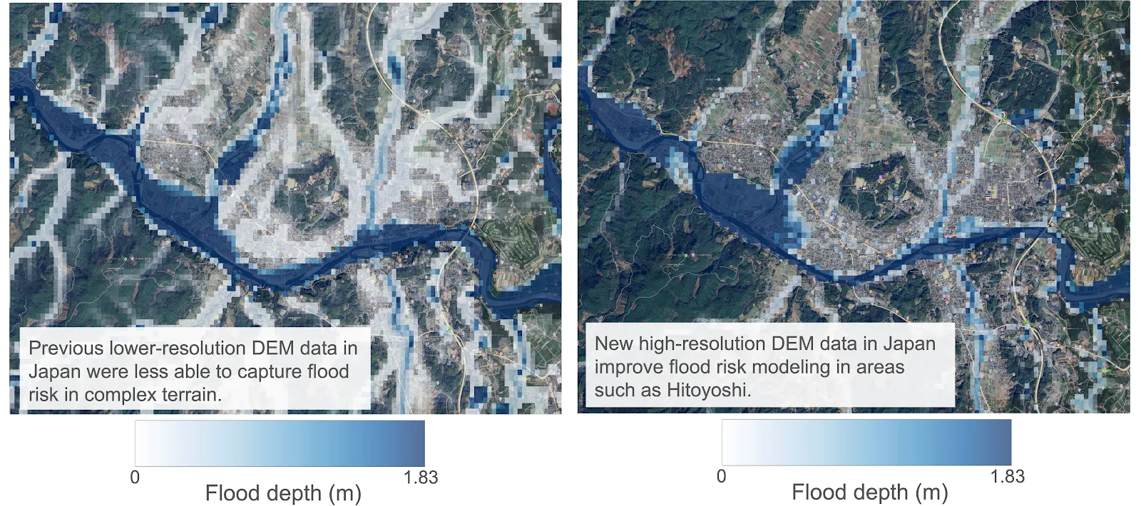
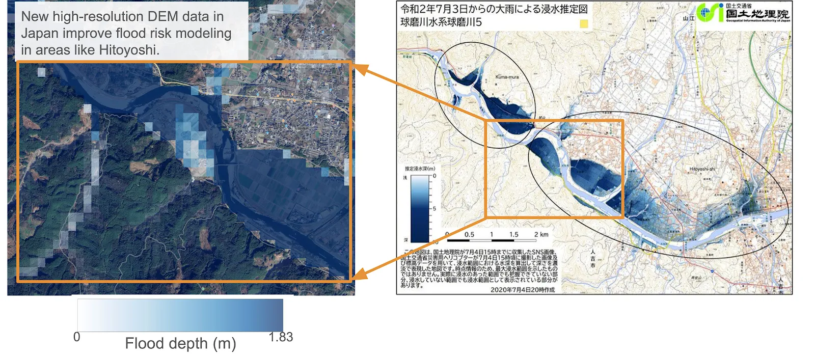
Real-world example: Southern Japan
In southern Japan, the updated DEMs improve the representation of complex terrain, leading to more accurate river and floodplain modeling. In Hitoyoshi (Kagoshima Prefecture), the new DEMs better characterize risk along the Kuma River, where many areas identified as high-risk were indeed affected during the July 2020 flood events1.
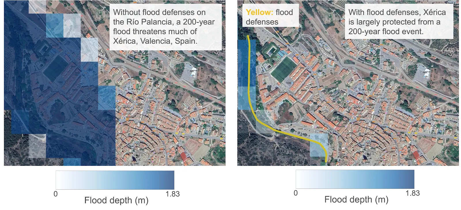
Expanded flood defense coverage improves local risk estimates
Flood defenses such as levees and floodwalls are essential for assessing actual exposure. ClimateScore Global incorporates new flood defense data for Spain and Japan and expands existing datasets across France, Germany, and the Netherlands.
For example, without defense modeling, low-lying areas of Xérica, Spain appear at risk during a 200-year flood event. When the existing levee along the Río Palancia is included, modeled risk is significantly reduced – reflecting the true level of protection for the community.
High-resolution pluvial modeling now covers more urban areas
Pluvial flooding – driven by extreme rainfall – is especially dependent on DEM resolution. With expanded LiDAR DEM coverage, ClimateScore Global enables expanded geographic coverage of high-resolution pluvial flood modeling, particularly in urban areas. In regions where 10-meter pluvial modeling is available, Jupiter MetricEngine can capture block-level variations that influence how rainfall accumulates and flows. These detailed insights are then coarsened appropriately for use in ClimateScore Global.
Example: Osaka’s Miyakojima Ward
- ClimateScore Global v3.0 (90m): Generalized inundation patterns.
- ClimateScore Global v3.3: The 10-meter modeling available through Jupiter MetricEngine reveals much finer distinctions in flood exposure between blocks within the neighborhood.
With an updated, high-resolution digital elevation model, we can expand coverage of Jupiter’s 10-meter pluvial flood model to more cities across the globe, allowing for detailed urban flood modeling.

Expanded high-resolution pluvial modeling coverage now includes major urban centers in Japan and Europe such as Spain, Portugal, Norway, Italy, Poland, Sweden, Finland, the United Kingdom, and Germany.
Key takeaways
ClimateScore Global delivers meaningful improvements to flood exposure modeling through more accurate terrain data and expanded flood defense information.
- LiDAR-based DEMs strengthen modeling in Europe and Japan, particularly in complex terrain.
- Expanded high-resolution pluvial modeling coverage improves our ability to represent urban flood risk.
- Broader defense datasets allow for more realistic local flood exposure assessments.
These updates underscore Jupiter’s continued commitment to improving data quality, reducing uncertainty, and providing the most reliable flood risk analytics available.
References
* “Kuma River flood estimated inundation”. Geospatial Information Authority of Japan (GSI). In “Information on the heavy rains of July 2020”. Accessed 23 November 2025. (in Japanese).
